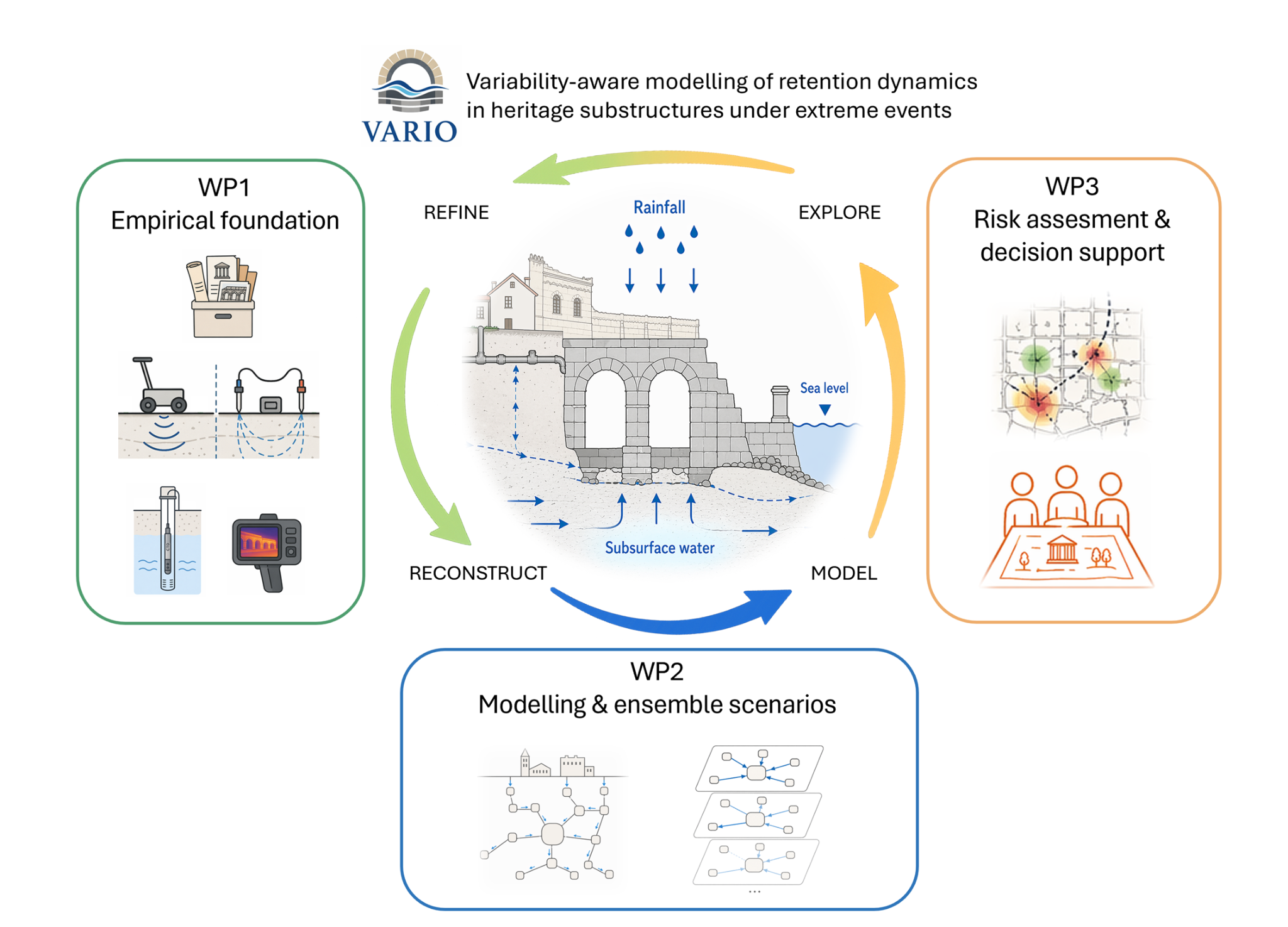
Identify the combinations
Which combinations of rainfall, coastal water levels and infrastructure conditions lead to critical water accumulation?


HRZZ research · Diocletian’s Palace, Split
How does water enter, move and persist beneath a living historic city? VARIO explores the interacting processes behind flooding and water retention in the substructures of Diocletian’s Palace.
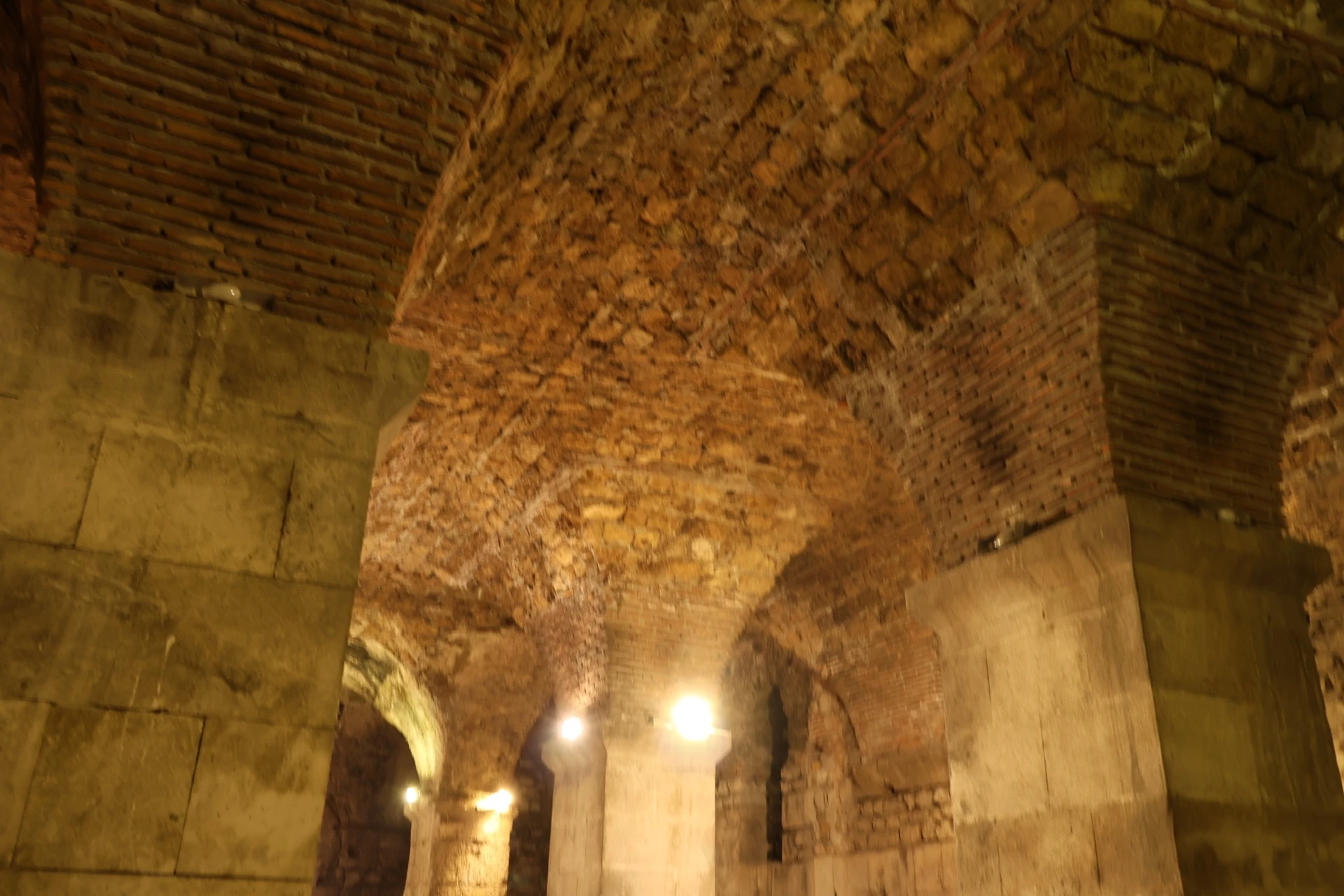
Diocletian’s Palace substructures · Photograph: Vladimir Divić
01 / The project
Extreme rainfall, sea-level variability, groundwater and infrastructure performance can interact. In heritage spaces, the depth of water matters—and so does how long it stays.
Variability-aware Modelling of Retention Dynamics in Heritage Substructures under Extreme Events
VARIO develops a hydraulic modelling approach for lower-level heritage spaces where drainage routes and subsurface connections are only partly documented. It combines system reconstruction, targeted observations and scenario ensembles to examine interacting drivers, thresholds and uncertainty.
The research is grounded in the substructures of Diocletian’s Palace. Modelling will begin in a priority western subdomain, with detail added where new evidence can improve the interpretation of water accumulation and retention.
The wider aim is a transferable approach for comparable enclosed or partly buried heritage spaces in coastal cities—connecting water science with conservation decisions.
Four research objectives
Which combinations of rainfall, coastal water levels and infrastructure conditions lead to critical water accumulation?
How do variability, uncertainty and dependence between drivers affect water depth and retention duration?
Where do spatial hotspots and threshold conditions intersect with archaeologically active and structurally sensitive areas?
How can modelling inform conservation, excavation planning and risk reduction in the historic city?
02 / Research approach
Three connected work packages move from evidence to hydraulic analysis and decision support. Observations inform models; model results help target the next observations.
Reconstruct water sources, pathways and storage zones from heterogeneous evidence. The conceptual model will explicitly distinguish what is observed, inferred and still unknown.
Start in the priority western subdomain, where observations can best constrain the system. Simplified hydraulic models will explore accumulation, inter-hall transfer and drainage across scenario ensembles.
Stress-test the system under plausible unfavourable combinations of rainfall, coastal water levels and infrastructure malfunction. Translate the ensemble results into spatially explicit guidance for heritage management.
Model detail follows the evidence. SWMM and HEC-RAS workflows will be adapted to the geometry, connectivity and observational constraints of the heritage setting.
Transparent assumptions, data provenance and sensitivity analysis are central to the research. The aim is to identify meaningful patterns without over-interpreting poorly constrained inputs.
03 / Preparatory evidence
Existing observations and exploratory tests help define the questions VARIO will investigate. These materials precede the project or support its methodological preparation.
LiDAR-derived surface drainage screening is compared with the reconstructed Roman drainage network. Spatial correspondence helps frame hypotheses about surface–subsurface connectivity; it does not demonstrate present-day hydraulic function.
Preparatory analysis. Historical drainage: Marasović, Perojević & Margeta, Građevinar 66(3), 2014.
Exploratory thermal screening is shown alongside documented leakage positions. Local temperature anomalies are consistent with some recorded ingress zones and help prioritise closer investigation.
Leakage documentation: A. Doljanin / ART CORE, January 2026. Thermal screening: March 2026. Preparatory evidence, preceding VARIO.
A preliminary SLAM survey of the eastern substructures provides a spatial basis for testing geometry preparation. Survey completeness, connectivity and geometric assumptions still require assessment.
Exploratory work supplied by the project team. Shown as methodological preparation, not a completed VARIO deliverable.
An exploratory flow test uses geometry from the eastern substructures. It illustrates a possible modelling workflow; the displayed water depths are scenario outputs, not observed flooding or a validated forecast.
Preliminary simulation. VARIO’s planned modelling begins in an empirically grounded priority western subdomain.
These visuals are preliminary evidence and methodological tests. They are not completed VARIO outputs. In particular, the eastern flow test is distinct from the western subdomain prioritised in the project plan.
Photographs give context to the spaces and visible features under investigation. They do not establish hydraulic connections or drainage performance.
04 / Science & place
Water science can help make uncertain conditions more understandable for the people who conserve, manage and study this living heritage.
Identify critical ingress and retention zones to support monitoring priorities and context-sensitive protective measures.
Clarify how water accumulation and persistence may affect archaeologically active and structurally sensitive spaces.
Develop transferable methods for analysing compound processes in enclosed heritage spaces with incomplete system knowledge.
05 / News & notes
Project announcements and preparatory research notes. New fieldwork, publications and datasets will be added as the research progresses.
A three-year programme connecting hidden water pathways, hydraulic modelling and heritage decisions.
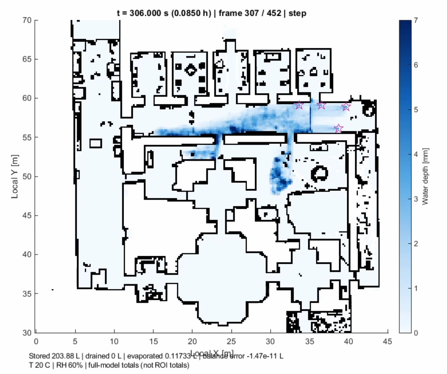
An exploratory test in the eastern substructures helps examine the path from survey data to model geometry.
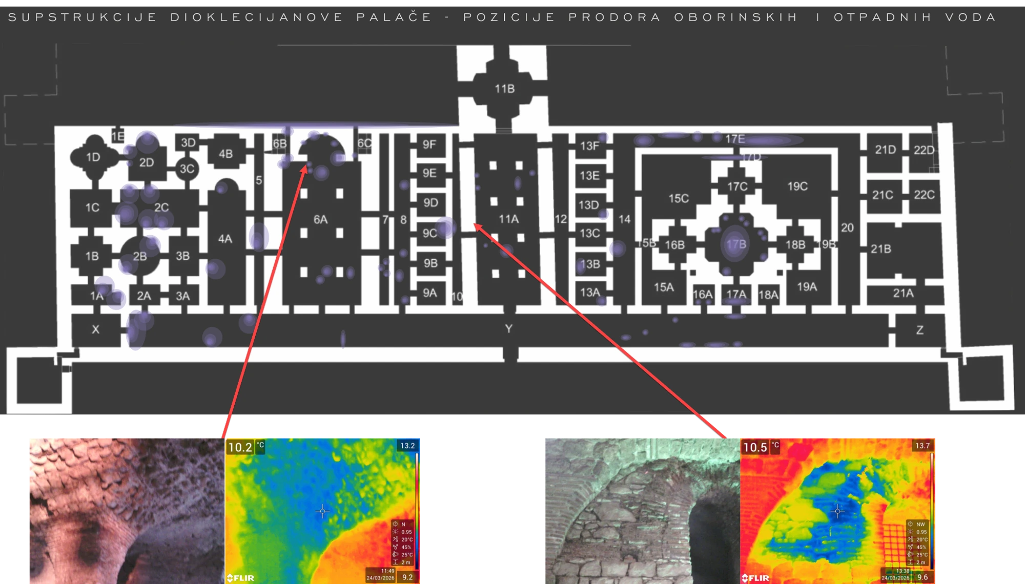
Thermal observations and conservation records help frame the questions for targeted investigations.
06 / Research team
The team connects hydraulic modelling, coastal processes and the spatial interpretation of heritage structures.
Assistant Professor · University of Split
Leads the scientific direction, integration across work packages and development of the modelling framework. Supervises scenario analysis and synthesis into scientific and decision-support outputs.
ORCID ↗Hydraulic modelling, scenario implementation, sensitivity analysis and spatial interpretation of model outputs.
Heritage structures, system reconstruction, geometric assumptions and the conservation context.
Marine boundary conditions, sea-level variability and interactions with precipitation-driven processes.
Faculty of Science, University of Split · Extreme sea levels and marine boundary conditions.
IIASA, Austria · Systemic risk, cascading effects and interpretation of compound events.
Museum of the City of Split · Site access, documentation and operational knowledge of the substructures.
A doctoral researcher role is planned through an application to HRZZ DOK-2026, subject to funding approval and formal recruitment. The intended research path covers field data, hydraulic model development, scenario ensembles and uncertainty analysis.
07 / Outputs & open science
Planned outputs will be linked here as they are completed. No project publications or public data releases are available yet.
Two planned journal papers will address system reconstruction and ensemble-based analysis of retention, interacting drivers and thresholds.
Selected derived datasets, documented model configurations and publication-supporting material are planned for repository release.
Spatial indicators of accumulation, persistence and critical pathways will support heritage decisions and a final stakeholder workshop.
Open science with clear access conditions: selected derived outputs are intended for Zenodo, with documentation and persistent identifiers. Third-party restrictions, site sensitivity and ongoing publication needs will be respected; not all raw data will be released openly.
08 / Contact & collaboration
For scientific exchange, site knowledge or collaboration related to VARIO, contact the principal investigator.
This project is funded by the Croatian Science Foundation through the Installation Research Projects programme (UIP), project no. 6629 — VARIO.
Host institution: Faculty of Civil Engineering, Architecture and Geodesy, University of Split. Scheduled start: 15 October 2026. Duration: 36 months.